Magnitude 8.8 Earthquake off Kamchatka Sends Tsunami Alerts Across the Pacific
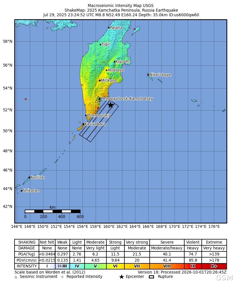
At 23:24:52 UTC on July 29, 2025, a magnitude 8.8 earthquake struck off Russia's Kamchatka Peninsula in the Russian Far East, with its epicenter about 119 kilometers east-southeast of Petropavlovsk-Kamchatsky and a depth of 35 kilometers. The U.S. Geological Survey (USGS) catalogued the event as us6000qw60; it was one of the largest earthquakes worldwide since Japan's magnitude 9.0 earthquake in 2011.
The USGS said the earthquake occurred as the result of shallow reverse faulting on the subduction zone interface along the Kuril-Kamchatka Trench. The mainshock was the latest in a sequence of earthquakes offshore of the peninsula that had begun ten days earlier, including a magnitude 7.4 earthquake on July 20.
The earthquake generated a Pacific-wide tsunami. The Pacific Tsunami Warning Center of the National Oceanic and Atmospheric Administration issued a tsunami warning for Hawaii, warnings for Northern California and the western Aleutian Islands, and tsunami advisories for the rest of the California coast and the coasts of Oregon and Washington. Gauges at Kahului, Hawaii, measured waves of more than 1.7 meters, and gauges across the Hawaiian Islands generally recorded more than one meter; no major damage was reported on the U.S. West Coast.
Local time at the epicenter was already the morning of July 30. Under this site's event-date convention, this story is archived under July 29, the Coordinated Universal Time date of the earthquake.
(Source: U.S. Geological Survey)
Source: U.S. Geological Survey
Published by GSM · USA (original Chinese edition)
Photo: 图:美国地质调查局发布的 2025 年堪察加半岛地震烈度图(ShakeMap),图头标注发震时刻为 2025 年 7 月 29 日 23 时 24 分 52 秒(UTC)、震级 8.8 级、震中北纬 52.49 度、东经 160.24 度、深度 35 公里,事件编号 us6000qw60。美国地质调查局,公共领域。 / Photo: Macroseismic intensity map (ShakeMap) of the 2025 Kamchatka Peninsula earthquake published by the U.S. Geological Survey; the header records July 29, 2025, 23:24:52 UTC, M8.8, 52.49N 160.24E, depth 35.0 km, event ID us6000qw60. U.S. Geological Survey, public domain.