NOAA Winter Outlook: Very Strong El Niño Points to a Warmer North and a Wetter South
The National Oceanic and Atmospheric Administration (NOAA) on October 15 released its U.S. Winter Outlook for December 2026 through February 2027: driven by a strengthening, very strong El Niño, the coming winter is expected to be warmer than average across much of the northern United States and wetter than average across the southern tier, with drought improving for most of the country.
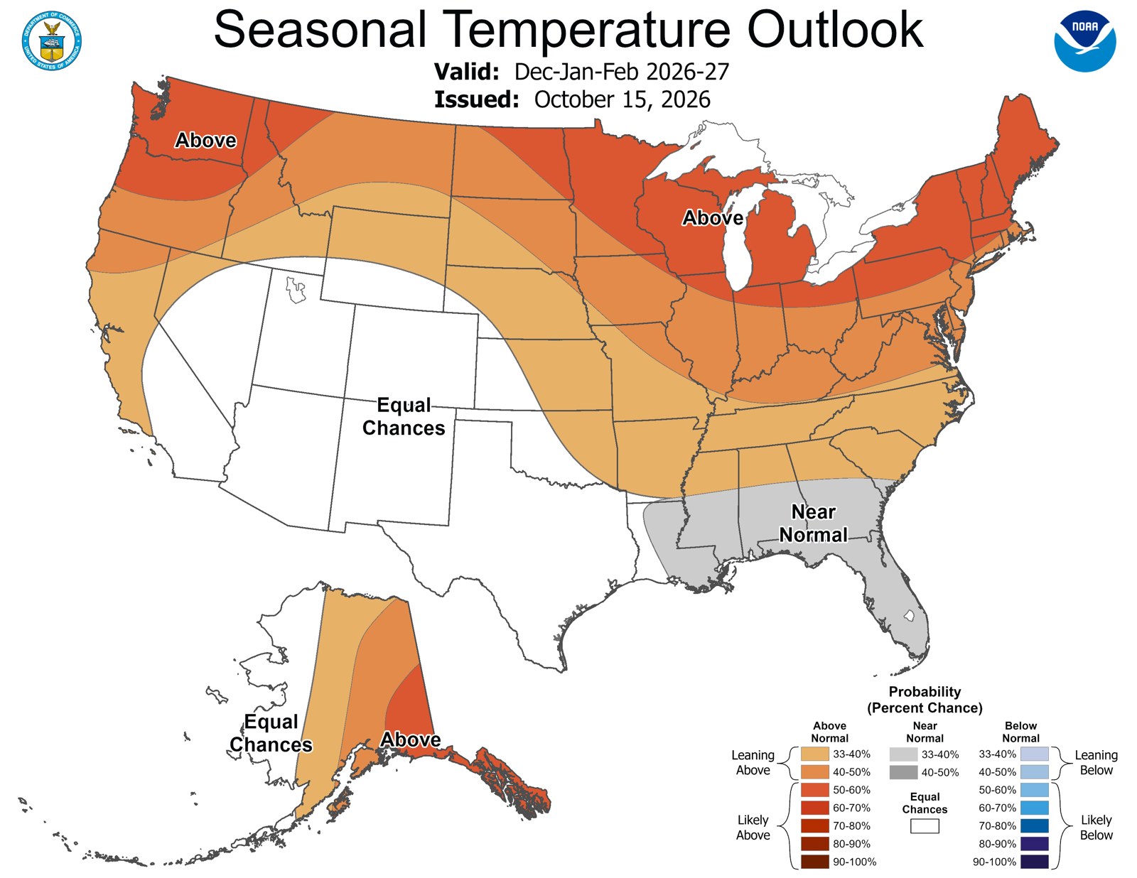
On temperature, the outlook favors above-average warmth for the Pacific Northwest, the northern Rockies, the Midwest, the Mississippi Valley, much of the East and Alaska, with the highest odds over Southeast Alaska, the upper Mississippi Valley and the Great Lakes. Parts of the Southeast, including Florida, are most likely to see near-normal temperatures, and no part of the country is forecast to be colder than normal. Much of the Southwest and Hawaii have equal chances of above-, near- or below-average temperatures.
On precipitation, wetter-than-average conditions are most likely from California, the Southwest, the Southern Plains and the lower Mississippi Valley through the Southeast and along the Eastern Seaboard, with the greatest likelihood in the Southeast and Florida. Drier-than-average conditions are favored for parts of the northern Rockies, the northern High Plains and the Great Lakes, as well as much of Alaska and Hawaii.
NOAA's Climate Prediction Center said the ongoing El Niño continues to strengthen, an El Niño advisory remains in effect, and the event is favored to continue through spring 2027, heavily influencing both the winter and spring outlooks. National Weather Service Director Ken Graham said in the release that a very strong El Niño will likely shift the jet stream southward and eastward, tilting the odds toward stormier weather across the South; added rain and snow can relieve drought, he said, but too much precipitation on dry soil can fuel flash floods and mudslides, and now is the time for communities and individuals to plan ahead.
The accompanying drought outlook, running from October 15 through January 2027, forecasts drought to improve or end in the Southwest, the Southern Great Plains, the Southeast and parts of the East Coast, while drought is favored to develop or worsen across parts of the northern Rockies, northeastern Oregon and eastern Washington.
NOAA also announced two service changes for this winter: the National Weather Service's Probabilistic Precipitation Portal is now operational, showing low-end, expected and high-end amounts of snow, ice and rain and the probabilities of exceeding thresholds; and select Blizzard Warnings and Ice Storm Warnings will this season use "Particularly Dangerous Situation" wording for high-confidence, historic storms.
NOAA notes that seasonal outlooks give the likelihood that temperatures and total precipitation will be above, near or below average, and do not project seasonal snowfall totals, which are generally predictable only about a week ahead. The Weather Prediction Center updates its three-month outlook monthly; the next update is due November 19.
Separately, NOAA has estimated an 83 percent chance that this El Niño becomes the strongest since 1950. NASA satellites have tracked warm water moving east across the equatorial Pacific since January, with eastern Pacific sea-surface temperatures running about 1.7 degrees Celsius above the long-term average.
Published by GSM · USA (original Chinese edition)
Photo: NOAA 2026—2027年冬季气温展望图(2026年10月15日发布)· 美国国家海洋和大气管理局,公共领域