Follow-Up: Camp Pendleton Henderson Fire Mapped at About 1,117 Acres; 41 Area Evacuation Ordered, I-5 Closed and Reopened
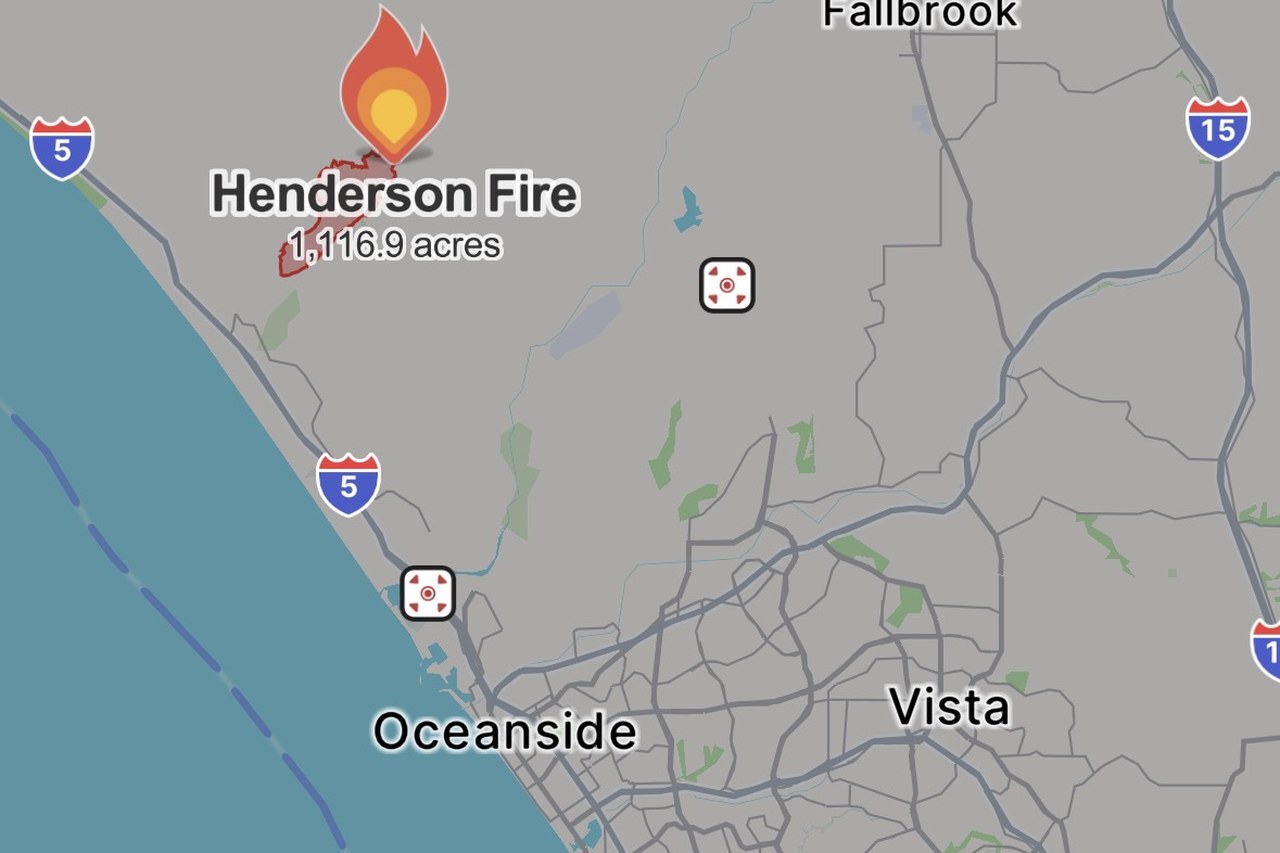
CAMP PENDLETON — The Henderson Fire, a brush fire that broke out on the afternoon of October 15 at Marine Corps Base Camp Pendleton in San Diego County, kept growing into the evening, prompting a new evacuation order on base and a temporary full closure of Interstate 5. Two size figures are in circulation, on different bases: Cal Fire's incident page, in a 3:25 p.m. text update, put the fire at 400 acres as measured from the air; by evening, official mapping data carried by the fire-tracking platform Watch Duty, sourced from the federal interagency wildfire geospatial database, showed a mapped fire perimeter of about 1,117 acres, and NBC 7 San Diego likewise reported that the fire had reached at least 1,117 acres. The first figure is an afternoon aerial estimate; the second is the acreage inside the subsequently mapped perimeter. As of publication, incident command had not released a revised confirmed burned acreage, and no containment figure has been announced. GSM's previous follow-up, published at 4:20 p.m., reported about 150 acres.
According to Cal Fire's incident page, at 5:13 p.m. the base issued an evacuation order for Las Flores (the 41 Area), directing affected personnel to evacuate to Paige Field House in the 11 Area; at 5:26 p.m., a secondary evacuation point was established at the 21 Area gym, according to the base's Facebook page. Evacuation orders issued earlier for areas on base remain in effect, and officials had issued no notice lifting them as of publication. The power outage around Las Pulgas (the 43 Area) continues, with no restoration notice issued. Outside the base, no evacuation orders or warnings had been issued for surrounding communities such as Oceanside as of publication; a smoke advisory is in effect for North County communities, according to local television reports.
Cal Fire issued a "threat to Interstate 5" alert for the fire at 4:11 p.m. At 5:09 p.m. the incident commander said I-5 would close in both directions between Harbor Drive and Basilone Road; the California Highway Patrol said the closure was in effect at 5:37 p.m., and at 5:49 p.m. CHP said the full reopening of I-5 was under way, though the highway may be closed again immediately if conditions require. Las Pulgas Road, between Brown Street and Stuart Mesa Road, and the Las Pulgas Gate remain closed.
Camp Pendleton firefighters, Cal Fire and assisting agencies continue the attack; four air tankers were assigned in the afternoon, and structures and power lines above the fire remain threatened. As of publication, officials had reported no injuries; as of 3:30 p.m. there were no reported structural damage, and no further damage reports have been issued since. The cause of the fire remains under investigation.
Background: the fire was reported shortly before 2 p.m. near Henderson Street and Brown Street in the western part of the base. Cal Fire logged it at 10 acres at 2:39 p.m., and east winds pushed it to about 75 acres by 2:43 p.m., 100 acres by 2:47 p.m., an estimated 100 to 150 acres by 2:52 p.m., and 400 acres by aerial measurement at 3:25 p.m. The fire is burning around the base's 43 Area; the base ordered evacuations for affected areas soon after it started, and an outage was reported in the Las Pulgas area. GSM's first report and first follow-up covered the ignition and the growth to about 150 acres; this is the second follow-up on the same incident thread.
(Sources: Cal Fire Henderson Fire incident page, updated through 5:49 p.m. Oct. 15; Watch Duty situation map and mapping data; NBC 7 San Diego; City News Service)
Source: GSM · USA (original Chinese edition)
Photo: 图片来源:Henderson Fire态势图,Watch Duty截图,10月15日18:44左右;图中火场周界与面积为该平台采用的官方测绘数据。Situation map of the Henderson Fire, screenshot from Watch Duty at about 6:44 p.m. on Oct. 15; the perimeter and acreage shown reflect official mapping data carried by the platform.
- 2026-10-15Henderson Fire Burns About 75 Acres on Camp Pendleton in San Diego County; Containment Not Yet Announced
- 2026-10-15Follow-Up: Camp Pendleton Henderson Fire Grows to About 150 Acres; Still No Evacuations Outside the Base
- 2026-10-15Follow-Up: Camp Pendleton Henderson Fire Mapped at About 1,117 Acres; 41 Area Evacuation Ordered, I-5 Closed and ReopenedThis story
- 2026-10-16Follow-Up: Camp Pendleton's Henderson Fire Grows to 2,080 Acres, Still 0% Contained; I-5 Closed in Both Directions Between Vandegrift and Basilone
- 2026-10-17Henderson Fire at Camp Pendleton Now 20% Contained at 2,079 Acres; I-5 Fully Reopened
- 2026-10-17Henderson Fire at Camp Pendleton Revised Up to 3,132 Acres; Containment Holds at 20%
- 2026-10-17Follow-Up: Henderson Fire at Camp Pendleton Reaches 50% Containment at 3,160 Acres
- 2026-10-17Roundup: All Four Southern California Wildfires Moving Toward Containment — Henderson at 50%, Norte Evacuations Fully Lifted
- 2026-10-18Follow-Up: Henderson Fire at Camp Pendleton Reaches 65% Containment as Crews Move to Mop-Up
- 2026-10-19Follow-Up: Henderson Fire at Camp Pendleton Reaches 95% Containment; Size Revised to 3,260 Acres on Precise Mapping
- 2026-10-19Update: Henderson Fire at Camp Pendleton Reaches 100% Containment at 3,260 Acres