Magnitude 7.7 Earthquake Strikes Central Myanmar Near Mandalay, Rupturing 475 Kilometers of the Sagaing Fault
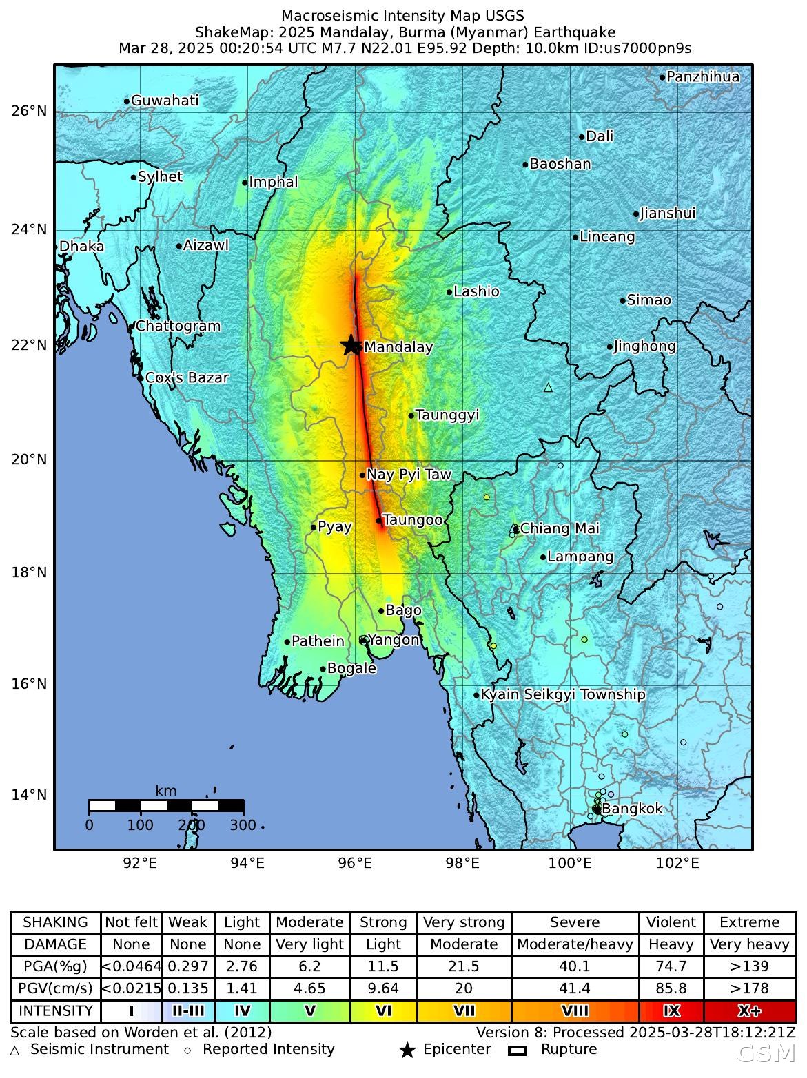
On March 28, 2025, at 12:50 p.m. local time, a moment magnitude 7.7 earthquake struck central Myanmar. The U.S. Geological Survey (USGS) located the epicenter in Myanmar's Sagaing Region, close to Mandalay, the country's second-largest city, at 22.011°N, 95.936°E and a depth of about 10 kilometers; about 11 minutes later, a magnitude 6.7 aftershock struck to the south of the epicenter.
The earthquake ruptured the Sagaing Fault, the great north-south fault running through central Myanmar. A USGS-led study later published in the journal Science found that the rupture tore through 475 kilometers of the fault — more than twice the length predicted by magnitude scaling relationships — at supershear velocities of more than 5 kilometers per second, exposing a vast population along the fault to violent shaking. The researchers compared the event to the magnitude 7.9 San Francisco earthquake of 1906, another atypically long and fast rupture.
Damage was concentrated in central Myanmar. In a situation report issued ten days after the earthquake, the U.N. Office for the Coordination of Humanitarian Affairs (OCHA), compiling publicly available figures, said more than 3,500 people had died across Myanmar, nearly 5,000 had been injured, and over 200 remained missing. An estimated 17.2 million people were living in affected areas, with over 9.1 million exposed to the strongest tremors across 58 townships; Mandalay Region, the capital Nay Pyi Taw, Sagaing Region, and southern Shan State were the most severely affected.
Urgent needs, OCHA said, included food, drinking water, healthcare, cash assistance, and emergency shelter. People left homeless were exposed to extreme heat during the country's hottest and driest month, and rain had already begun in Mandalay, posing an additional threat to those sheltering in the open. The casualty figures above are the ten-day tally and were updated further in later reporting. (Source: U.S. Geological Survey)
Source: U.S. Geological Survey
Published by GSM · USA (original Chinese edition)
Photo: 图:美国地质调查局(USGS)本事件ShakeMap烈度图(事件us7000pn9s):2025年3月28日缅甸曼德勒7.7级地震,震中位于曼德勒附近、实皆断裂带破裂带纵贯缅甸中部(美国地质调查局,公共领域,Wikimedia Commons)。 / Image: USGS ShakeMap intensity map for this event (us7000pn9s), the March 28, 2025 M7.7 Mandalay, Myanmar earthquake, with the epicenter near Mandalay and the Sagaing Fault rupture running through central Myanmar (U.S. Geological Survey, public domain, via Wikimedia Commons).