Follow-Up: Azusa Peak Fire Remapped at 43 Acres as Containment Rises to 41%
AZUSA — The Peak Fire, a brush fire that broke out on the afternoon of October 15 in the foothills north of San Gabriel Canyon Road in Azusa, Los Angeles County, has been remapped by aerial survey at 43 acres. According to officials with the U.S. Forest Service's Angeles National Forest, part of the unified command, containment had risen to 41% as of 4:45 p.m., and the fire's spread has been halted. The 43-acre figure is a downward revision from more precise aerial mapping, not an actual shrinking of the fire on the ground: GSM's previous follow-up, based on incident command's figure at the time, put the size at about 60 acres. The 41% figure is also the first containment number released by unified command, which had not previously announced one.
Evacuation status is unchanged: no zone remains under an evacuation order. Zones still under an evacuation warning are AZU-MC01 (downgraded from an order), LAC-E168-B and LAC-E170-B; warnings for six other zones — AZU-ABC01, AZU-CYN01-A, AZU-NOB01, AZU-QRY01, LAC-E168-A and LAC-E170-A — were lifted earlier. The evacuation shelter at the Azusa Memorial Park Recreation Center, 340 N Orange Ave, remains open. The Cal Fire incident page for the Peak Fire still showed its 2:21 p.m. version as of publication (22 acres, no containment listed, evacuation section not yet updated), so the acreage, containment and evacuation status here follow the latest briefing from Angeles National Forest officials.
The Los Angeles County Fire Department and the Angeles National Forest continue the firefight under unified command, with water-dropping helicopters drawing from a nearby reservoir and ground crews holding structure protection on the slopes above homes near Foxtail Court and Poppyglen Court. As of publication, officials had issued no reports of injuries or structures damaged, and the cause remains under investigation. The National Weather Service Red Flag Warning covering much of Los Angeles County remains in effect through 8 p.m. Saturday, and fire danger remains elevated.
Background: the fire ignited shortly after 1 p.m. on slopes near San Gabriel Canyon Road, Mirador Drive and Ranch Road; the County Fire Department called a second alarm at 1:34 p.m., and Cal Fire lists the start time as 1:43 p.m. It grew rapidly over several hours, with incident command at one point putting it at roughly 50 to 60 acres. Zone AZU-MC01 was placed under an evacuation order and eight surrounding zones under warnings before the order was downgraded in the late afternoon and most warnings were lifted. GSM's first report and first follow-up covered the ignition, the evacuation order and its downgrade; this is the second follow-up on the same incident thread.
(Sources: Angeles National Forest officials' briefing, via MyNewsLA; Cal Fire Peak Fire incident page, updated 2:21 p.m. Oct. 15)
Source: GSM · USA (original Chinese edition)
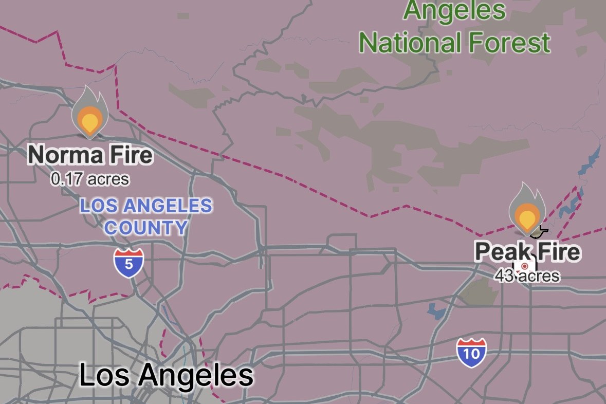
Photo: Peak Fire 态势图,Watch Duty 截图,10 月 15 日晚:火场位于阿祖萨以北的圣盖博山麓、安吉利斯国家森林南缘、10 号公路以北,图中标注 43 英亩,与官方晚间测绘修正口径一致。图片来源:Watch Duty。 Situation map of the Peak Fire, Watch Duty screenshot, evening of Oct. 15: the fire sits in the San Gabriel foothills north of Azusa, along the southern edge of Angeles National Forest and north of Interstate 10; the 43 acres shown matches the official remapped figure. Source: Watch Duty.
- 2026-10-15Peak Fire in Azusa Grows to 22 Acres; Evacuation Order in Effect as Helicopters Drop Water to Protect Homes
- 2026-10-15Follow-Up: Azusa Peak Fire Grows to About 60 Acres; AZU-MC01 Order Downgraded to a Warning
- 2026-10-15Follow-Up: Azusa Peak Fire Remapped at 43 Acres as Containment Rises to 41%This story
- 2026-10-17Roundup: All Four Southern California Wildfires Moving Toward Containment — Henderson at 50%, Norte Evacuations Fully Lifted