瓦努阿图Port-Olry西北海域发生6.0级地震:震源深度10公里,同日多次5级左右地震
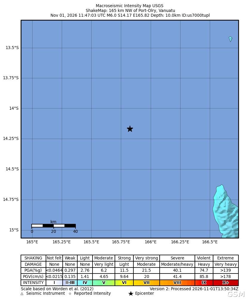
南太平洋岛国瓦努阿图近海11月1日发生6.0级地震。据美国地质调查局(USGS)实时事件记录(事件编号 us7000tupl),地震发生于协调世界时11月1日11时47分(美西时间1日凌晨3时47分、瓦努阿图当地时间1日晚间10时47分),震中位于瓦努阿图 Espiritu Santo 岛 Port-Olry 西北约165公里海域,震源深度10公里。
USGS 将此次地震的警报级别定为绿色,意为预计造成人员伤亡与经济损失的可能性较低;其震动强度图(ShakeMap)测得的最大震度约为4.1级,属轻微震动。USGS 实时记录未对此次地震发出海啸提示。截至美西时间1日晚间,未见当地伤亡或财产损失的报告。
这并非该海域当天唯一一次地震:同日更早时段,同一带海域已先后发生5.4级(协调世界时6时26分)、5.1级(7时整)与4.7级(7时37分)地震;6.0级主震之后,又记录到两次4.8级余震(11时56分与12时08分),这一带当日4.7级以上地震共6次,震源深度均为10公里。
瓦努阿图位于环太平洋火山地震带,地壳活动频繁。就在两天前的10月30日,Port-Olry 东南偏东海域曾发生6.2级地震,但那次震源深度达142.8公里,与本次浅层地震位置与深度均不同。
关联:瓦努阿图发生6.2级地震:震中位于Port-Olry东南偏东43公里,震源深142.8公里
Magnitude 6.0 Earthquake Strikes Northwest of Port-Olry, Vanuatu: Shallow 10 km Focus, Several Magnitude-5 Shocks the Same Day
A magnitude 6.0 earthquake struck offshore near the South Pacific island nation of Vanuatu on November 1. According to the U.S. Geological Survey (USGS) real-time event record (event ID us7000tupl), the quake occurred at 11:47 UTC on November 1 (3:47 a.m. Pacific Time, 10:47 p.m. local time in Vanuatu), with its epicenter about 165 km northwest of Port-Olry on Espiritu Santo island, at a depth of 10 km.
USGS assigned the earthquake a green alert, meaning a low likelihood of casualties and economic loss; its ShakeMap put peak shaking intensity at about 4.1, a light level. The USGS record carried no tsunami designation for the event. As of Sunday evening Pacific Time, there were no reports of casualties or property damage.
It was not the only earthquake in those waters that day: the same area had already recorded magnitude 5.4 (06:26 UTC), 5.1 (07:00 UTC) and 4.7 (07:37 UTC) shocks earlier on November 1, and two magnitude 4.8 aftershocks followed the mainshock at 11:56 and 12:08 UTC, six events of magnitude 4.7 or above in the area for the day, all at 10 km depth.
Vanuatu sits on the Pacific Ring of Fire and experiences frequent seismic activity. On October 30, a magnitude 6.2 earthquake struck east-southeast of Port-Olry in the same broader region, but at a depth of 142.8 km, differing from Sunday's shallow event in both location and depth.
来源:GSM·美国(原文链接)
图片来源:图:美国地质调查局(USGS)发布的本次地震震动强度图(ShakeMap),星号为震中,位于瓦努阿图Port-Olry西北海域。图片:USGS,公共领域。 / ShakeMap for this earthquake published by the U.S. Geological Survey (USGS); the star marks the epicenter, northwest of Port-Olry, Vanuatu. Image: USGS, public domain.
GSM Global · 本篇英文版 English edition of this story