Four Atmospheric Rivers in a Row Aim at the Pacific Northwest, With Up to 7 Inches of Rain on the Olympic Peninsula
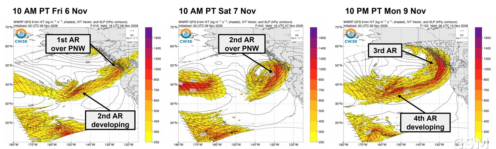
The Pacific Northwest is in the middle of a parade of atmospheric rivers. In its atmospheric river outlook issued November 6, the Center for Western Weather and Water Extremes (CW3E) at UC San Diego's Scripps Institution of Oceanography said a moderate-strength atmospheric river made landfall over British Columbia and the Pacific Northwest on Thursday, November 5, to be followed by a second, stronger one on Saturday, November 7 into Sunday, November 8, with a third forecast to begin Monday, November 9 and a fourth on Tuesday, November 10, producing a long-duration period of atmospheric river conditions.
On rainfall, the National Weather Service's Weather Prediction Center forecasts 2 to 4 inches over Washington's Olympic Peninsula and the far northern Cascades from the first two atmospheric rivers. The third and fourth together are forecast to bring 3 to 7 inches over the Olympic Peninsula and the Cascades, 1.5 to 2.5 inches in the Klamath Mountains, and 0.5 to 1.5 inches broadly over coastal Washington, Oregon and Northern California. CW3E's ensemble landfall tools put the probability of further atmospheric river activity over the Pacific Northwest and Northern California on November 13-15 at 70 to 90 percent.
Flood risk is currently low overall. The NOAA and National Weather Service Hydrologic Ensemble Forecast Service shows only 10 gages in Washington with a 10 percent chance of exceeding action stage and one gage with a 10 percent chance of exceeding minor flood stage over the next 10 days. The Stehekin River in northern Washington, however, has a 34 percent probability of exceeding minor flood stage and a 63 percent probability of exceeding action stage over that period.
With freezing levels staying near 5,000 feet, precipitation from these atmospheric rivers is expected to fall mainly as rain across the watersheds, except at the highest elevations. The National Weather Service Climate Prediction Center has also highlighted risks of heavy precipitation and coastal high winds over western Washington, Oregon and northern California on November 13-15, with heavy snow possible in the southern Cascades and the Sierra Nevada. (Source: Scripps Institution of Oceanography, UC San Diego)
Source: Scripps Institution of Oceanography, UC San Diego
Published by GSM · USA (original Chinese edition)
Photo: 图:西部天气与水极端事件中心(CW3E)11月6日大气河流展望所附预报图。加州大学圣迭戈分校斯克里普斯海洋研究所 CW3E。 / Image: Forecast graphic from CW3E's November 6 atmospheric river outlook. CW3E, Scripps Institution of Oceanography, UC San Diego.