Henderson Fire at Camp Pendleton Now 20% Contained at 2,079 Acres; I-5 Fully Reopened
SAN DIEGO COUNTY — Firefighters have made their first measurable progress on the Henderson Fire, a brush fire burning at Marine Corps Base Camp Pendleton, as it entered its third day. According to updates posted on the CAL FIRE incident page through Friday evening, October 16, the fire's mapped size stands at 2,079 acres and containment has risen from 0% to 20%. Interstate 5, twice closed in both directions because of flames and smoke, fully reopened on Friday afternoon. As of publication, officials had issued no new evacuation orders and reported no destroyed structures and no injuries; the cause remains under investigation.
On containment, CAL FIRE announced at 6:12 p.m. Friday that the fire was 20% contained — the first containment figure reported since the fire began on October 15, after more than a day at zero containment. In its evening update, CAL FIRE said the San Diego County Incident Management Team had been assigned to support the Henderson Fire, providing additional leadership and coordination across command, operations, planning, logistics and finance, and that firefighters would continue building containment lines, extinguishing hot spots and addressing hazards. Rugged terrain and strong Santa Ana winds remain the biggest challenges. The Camp Pendleton Fire Department holds jurisdiction over the fire, with CAL FIRE and other agencies assisting.
On roads, the fire crossed containment lines on its northwest side around midday Friday and smoke cut visibility on both sides of Interstate 5. The California Highway Patrol (CHP) first closed the northbound lanes at Vandergrift Boulevard at 12:16 p.m., then put a full closure in effect in both directions between Vandergrift Boulevard and Basilone Road, with active flames on both sides of the freeway. As conditions eased toward evening, the northbound lanes reopened first; at 5:14 p.m., CAL FIRE relayed the CHP's announcement that all northbound and southbound lanes of I-5 were open again. According to Amtrak Pacific Surfliner service advisories, trains were suspended for a time on Friday between Oceanside and San Clemente Pier. On the base itself, Las Pulgas Road between Brown Street and Stuart Mesa Road, and the Las Pulgas Gate, remained limited to emergency vehicles as of Friday evening.
On evacuations, the order for the base's Las Flores (41 Area) had already been lifted at 7:31 p.m. on October 15. Temporary evacuation points were set up at the Paige Field House in the 11 Area and the 21 Area Fitness Center. No evacuation orders have been issued for surrounding off-base communities, and the latest official updates announced no new evacuation orders or warnings.
A second blaze, the Scales Fire, ignited on Friday along Interstate 5 near the San Onofre checkpoint, in the same general area as the Henderson Fire. Crews fighting the larger fire also responded to the Scales Fire and stopped its spread at approximately 20 acres.
The Henderson Fire was first reported at 2:35 p.m. on October 15 near Henderson Street and Brown Street, close to Basilone Road and Las Pulgas Road, in the western part of Camp Pendleton. Pushed by easterly winds, it grew to roughly 400 acres within 90 minutes and was mapped at 1,404 acres that evening, prompting the 41 Area evacuation order and the first closure and reopening of I-5. By midday Friday it had reached 2,080 acres — later revised by mapping to 2,079 acres — with containment still at zero and I-5 closed in both directions for a second time. By Friday evening, containment had climbed to 20% and the freeway was fully open, the fire's latest status as of publication.
Source: GSM · USA (original Chinese edition)
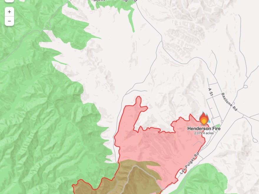
Photo: 图:Henderson Fire 态势图,Watch Duty 截图(10月16日13时50分截取,局部裁切)。图中红色周界为火场范围(2,079.4英亩),位于彭德尔顿营西侧、Las Pulgas路一带,西南侧橄榄色区域为疏散分区。图片来源:Watch Duty。Situation map of the Henderson Fire, Watch Duty screenshot taken at 1:50 p.m. on Oct. 16 (cropped). The red perimeter (2,079.4 acres) lies on the west side of Camp Pendleton, along Las Pulgas Road, with the evacuation zone shaded olive at its southwest. Source: Watch Duty.
- 2026-10-15Henderson Fire Burns About 75 Acres on Camp Pendleton in San Diego County; Containment Not Yet Announced
- 2026-10-15Follow-Up: Camp Pendleton Henderson Fire Grows to About 150 Acres; Still No Evacuations Outside the Base
- 2026-10-15Follow-Up: Camp Pendleton Henderson Fire Mapped at About 1,117 Acres; 41 Area Evacuation Ordered, I-5 Closed and Reopened
- 2026-10-16Follow-Up: Camp Pendleton's Henderson Fire Grows to 2,080 Acres, Still 0% Contained; I-5 Closed in Both Directions Between Vandegrift and Basilone
- 2026-10-17Henderson Fire at Camp Pendleton Now 20% Contained at 2,079 Acres; I-5 Fully ReopenedThis story
- 2026-10-17Henderson Fire at Camp Pendleton Revised Up to 3,132 Acres; Containment Holds at 20%
- 2026-10-17Follow-Up: Henderson Fire at Camp Pendleton Reaches 50% Containment at 3,160 Acres
- 2026-10-17Roundup: All Four Southern California Wildfires Moving Toward Containment — Henderson at 50%, Norte Evacuations Fully Lifted
- 2026-10-18Follow-Up: Henderson Fire at Camp Pendleton Reaches 65% Containment as Crews Move to Mop-Up
- 2026-10-19Follow-Up: Henderson Fire at Camp Pendleton Reaches 95% Containment; Size Revised to 3,260 Acres on Precise Mapping
- 2026-10-19Update: Henderson Fire at Camp Pendleton Reaches 100% Containment at 3,260 Acres