Magnitude 7.0 Earthquake Hits Baqen County in Nagqu, China's Tibet Region: National Emergency Response Launched as Damage Checks Continue
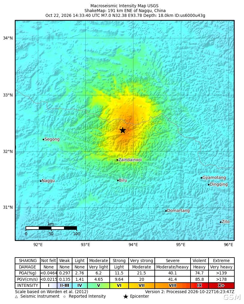
NAGQU — A magnitude 7.0 earthquake struck Baqen County in Nagqu, in China's Tibet Autonomous Region, at 10:33 p.m. Beijing time on Thursday (14:33 GMT), the China Earthquake Networks Center (CENC) said, with a focal depth of 10 kilometers (6.2 miles), at 32.40 degrees north latitude and 93.79 degrees east longitude. The U.S. Geological Survey (USGS) also measured the quake at magnitude 7.0, placing the epicenter about 191 kilometers (119 miles) east-northeast of Nagqu at a depth of 18 kilometers, with a maximum intensity of VIII (severe). Reuters said it was the strongest earthquake to hit China since January 2024; the epicenter is about 400 kilometers from Lhasa, the regional capital, and the tremor was clearly felt in the local area.
CENC data show the average elevation within 5 kilometers of the epicenter is about 4,864 meters, in a sparsely populated area; townships including Gangqie and Maru lie within 20 kilometers of the epicenter, and shaking was also felt in Lhasa, Nyingchi and Qamdo. Hong Kong media reported collapsed buildings and damaged walls in Maru Township in Baqen County, and local reports said rockfalls damaged a car and guardrails and blocked a section of National Highway 317 in the county. As of publication, Chinese authorities had not released casualty figures, and Reuters said it was not immediately known whether there were casualties.
After the quake, the China Earthquake Administration activated a Level-II emergency response, while the office of the State Council's earthquake relief headquarters and the Ministry of Emergency Management activated a national Level-IV earthquake disaster emergency response and dispatched a work team to the area. Emergency Management Minister Zhang Chengzhong directed the response by video link, calling for the damage to be verified as quickly as possible and for rescue, relocation and monitoring work to be carried out in full.
The USGS PAGER assessment system issued a yellow alert for shaking-related fatalities and an orange alert for economic losses, assessing that some casualties are possible and that significant damage is likely; most buildings near the epicenter are adobe block and unreinforced brick structures that are vulnerable to shaking. The agency estimated that several thousand people experienced very strong to severe shaking and tens of thousands felt strong shaking.
Tibet sits on the collision zone between the Indian and Eurasian plates and is prone to powerful earthquakes. In 2010, a magnitude 7.1 earthquake struck Yushu in neighboring Qinghai Province, about 280 kilometers away, killing at least 2,698 people and leaving nearly 300 people missing.
Published by GSM · USA (original Chinese edition)
Photo: 美国地质调查局(USGS)发布的本次地震烈度分布图(ShakeMap):震中位于中国西藏那曲市东偏北约191公里处,震级7.0级,最大烈度VIII度。美国联邦政府作品,公共领域(经 Wikimedia Commons 取得)。USGS ShakeMap of the October 22, 2026 magnitude 7.0 earthquake near Nagqu, Tibet, China, showing maximum intensity VIII. U.S. Geological Survey, public domain, via Wikimedia Commons.
- 2026-10-22Magnitude 7.0 Earthquake Hits Baqen County in Nagqu, China's Tibet Region: National Emergency Response Launched as Damage Checks ContinueThis story
- 2026-10-22Baqen Earthquake Follow-up: At Least 16 Dead and 339 Homes Collapsed in Nagqu, China's Tibet Region, Xinhua Reports
- 2026-10-22Baqen Earthquake Follow-up: Official Injured Toll Revised to 46, Death Toll Stays at 16 in Nagqu, China's Tibet Region
- 2026-10-22Baqen Earthquake Follow-up: Injured Toll Rises to 54 as China Raises National Earthquake Response to Level III in Nagqu, Tibet
- 2026-10-22Baqen Earthquake Follow-up: Injured Toll Rises to 65 as 12,489 Residents Are Safely Relocated in Nagqu, Tibet, China
- 2026-10-23Follow-Up: 7.0-Magnitude Earthquake in Baqing, Tibet Kills 16, Injures 76; Over 12,400 Evacuated as NDRC Allocates 30 Million Yuan