Follow-Up: Malibu Bryson Fire Reported at About 200 Acres as Red Cross Opens Shelter at Agoura High School
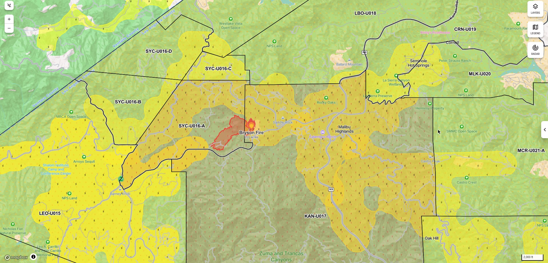
MALIBU — The Bryson Fire, a brush fire burning in the hills north of Malibu in Los Angeles County, continued to grow on the night of October 15. As of 9:30 p.m., authorities said the fire had grown to about 200 acres, the Ventura County Star reported, and the New York Post and other outlets also reported on Thursday night that the fire had passed 200 acres. Cal Fire's official incident page, however, still listed 101.5 acres in its latest update, posted at 7:07 p.m. (the acreage itself was reported at 6:31 p.m.); officials have not yet updated the official figure to 200 acres. Cal Fire lists the Los Angeles County Fire Department as the agency having jurisdiction; the cause remains under investigation, and no containment figure has been announced. Earlier in the evening, the Los Angeles County Sheriff's Department had cited its helicopter coordinator's estimate that the fire could reach approximately 200 acres within the hour.
On evacuations, Cal Fire's incident page shows evacuation orders now covering two zones, KAN-U017 and SYC-U016-A. Zone SYC-U016 was split into four sub-zones — A, B, C and D — during the evening, with SYC-U016-A upgraded to an order; when GSM last reported, the order covered only KAN-U017. Evacuation warnings have increased from 10 zones to 12: CRN-U019, LBO-U018, LEO-U015, MAL-C113, MAL-C114, MCR-U021-A, MLK-U020, SYC-U016-B, SYC-U016-C, SYC-U016-D, VST-U046 and WLV-C201, covering a broad swath of western Malibu's mountains and coast and extending west toward Leo Carrillo State Park. Residents can check their zone status through Alert LA County and Genasys Protect.
For shelter, the American Red Cross Los Angeles Region announced on the evening of October 15 that, in coordination with Los Angeles County, it has opened an emergency shelter at Agoura High School, 28545 W. Driver Ave, Agoura Hills, CA 91301. The shelter is open now to residents affected by the fire and offers water and snacks, disaster health services and emotional support; the Red Cross can be reached at 1-800-733-2767. On road closures, the Malibu/Lost Hills Sheriff's Station announced closures at Kanan Road and Mulholland Highway, Westlake Boulevard and Mulholland Highway, and Encinal Canyon Road and Decker Road. Los Angeles County Animal Care and Control said the Agoura Animal Care Center, 29525 Agoura Road, is open to receive pets of affected residents, and horses can be temporarily stabled free of charge at ETI Corral 37 at Conejo Creek Equestrian Park in Thousand Oaks.
County fire crews and aircraft continued working through the night, with night-flying helitankers continuing water drops, and the Ventura County Fire Department continued sending equipment and personnel to assist. The National Weather Service expects winds near the fire to increase further overnight into early Friday, with gusts of 50 to 60 mph possible; the Red Flag Warning remains in effect through 8 p.m. Saturday. The Getty Villa announced it will be closed on Friday, October 16, to help keep surrounding roads clear for emergency responders, and the Santa Monica-Malibu Unified School District said it will announce by 6:30 a.m. Friday whether Malibu schools will be in session. As of publication, there were still no reports of injuries, and initial reports from the scene indicated that no structures were threatened.
Background: the fire was reported around 4:30 p.m. in the 400 block of Encinal Canyon Road, near Mulholland Highway and the county's Camp Kilpatrick juvenile detention facility. Driven by Santa Ana winds, it grew from about half an acre to roughly 20 acres within half an hour and had passed 40 acres by early evening; GSM's previous report (Cal Fire's 6:19 p.m. figures) put it at 80 acres with warnings expanded to 10 zones. The fire erupted while central and western Malibu were under a Southern California Edison Public Safety Power Shutoff (PSPS).
(Sources: Cal Fire Bryson Fire incident page, updated 7:07 p.m., Oct. 15, 2026, with official acreage of 101.5 acres reported at 6:31 p.m.; American Red Cross Los Angeles Region press release, Oct. 15, 2026; Ventura County Star, New York Post and Malibu Times reports on the night of Oct. 15)
Source: GSM · USA (original Chinese edition)
Photo: 图:Bryson Fire 态势图,Watch Duty 截图,10月15日22时许。图中标注分区为疏散令(2个分区)与疏散警告(12个分区)覆盖区域,火场周界为态势平台最新测绘范围;Cal Fire公布的官方过火面积为101.5英亩(10月15日18:31通报)。Bryson Fire incident map, Watch Duty screenshot, captured at about 10 p.m. on Oct. 15. The zones shown are the areas under evacuation orders (2 zones) and warnings (12 zones), and the fire perimeter is the platform's latest mapped perimeter; Cal Fire's posted official acreage is 101.5 acres (reported 6:31 p.m., Oct. 15).
- 2026-10-15Malibu Bryson Fire Grows to at Least 40 Acres; Evacuation Order Issued for Zone KAN-U017
- 2026-10-15Follow-Up: Malibu Bryson Fire Grows to 80 Acres as Evacuation Warnings Expand to 10 Zones
- 2026-10-15Follow-Up: Malibu Bryson Fire Reported at About 200 Acres as Red Cross Opens Shelter at Agoura High SchoolThis story
- 2026-10-16Bryson Fire Update: Containment Rises to 39% as Mapped Acreage Is Revised to 146.2 Acres
- 2026-10-17Bryson Fire in Malibu Reaches 52% Containment; Size Holds at About 147 Acres
- 2026-10-17Update: All Bryson Fire Evacuation Orders and Warnings Lifted Near Malibu; Roads Reopened, Shelters Closed
- 2026-10-17Roundup: All Four Southern California Wildfires Moving Toward Containment — Henderson at 50%, Norte Evacuations Fully Lifted
- 2026-10-18Update: Bryson Fire Near Malibu Reaches 68% Containment; Size Holds at About 147 Acres
- 2026-10-18Update: Bryson Fire Near Malibu Reaches 74% Containment; Size Holds at About 147 Acres
- 2026-10-19Follow-Up: Bryson Fire Near Malibu Reaches 83% Containment; Size Holds at 147 Acres
- 2026-10-20Follow-Up: Bryson Fire Near Malibu Fully Contained; Size About 146 Acres