Update: All Bryson Fire Evacuation Orders and Warnings Lifted Near Malibu; Roads Reopened, Shelters Closed
The Los Angeles County Sheriff's Department (LASD) announced via Nixle on the evening of October 17 that all evacuation orders and warnings for the Bryson Fire near Malibu have been lifted, with two zones downgraded to advisories — residents there should stay alert and be ready to evacuate if conditions change. Firefighters continue to work across the 146-acre fire footprint to extinguish all hot spots and move toward full containment.
The two agencies' latest figures differ: CAL FIRE reported on the morning of October 17 that aerial mapping put the fire at 146.2 acres (about 147 acres) with containment at 52%. The Sheriff's Department's evening update gave no new containment figure, saying only that crews are working across the footprint toward 100% containment.
The National Weather Service's Red Flag Warning for Los Angeles County expired at 6 p.m. this evening. All roads closed because of the fire have reopened to the public, including Topanga Canyon Boulevard. Planned precautionary power shutoffs are being canceled, and utilities are restoring power to sites shut down yesterday to limit fire risk.
The resident shelter at Agoura High School has closed, as has the large-animal shelter at Pierce College; the Agoura Animal Care Center has returned to regular hours. The 38 youths temporarily relocated to Barry J. Nidorf Juvenile Hall will be returned to Campus Vernon Kilpatrick by the county Probation Department.
The Sheriff's Department said no structures were lost or damaged and fire personnel sustained only minor injuries. The fire started on Thursday, October 15, at about 4:41 p.m. near Encinal Canyon Road, and more than 414 emergency personnel were assigned at the height of the response, according to LASD.
Source: GSM · USA (original Chinese edition)
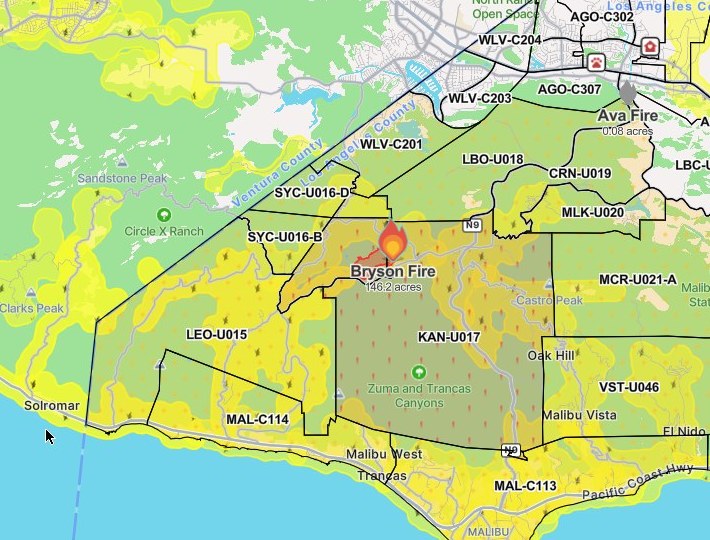
Photo: 图:Bryson Fire 态势图,Watch Duty 截图(10月16日20时45分截取,局部裁切)。图中KAN-U017为疏散令分区、周边黄色区域为疏散警告分区——该批疏散令与警告已于10月17日晚全部解除。最新官方数据以正文为准:过火面积146.2英亩、控制率52%(加州消防局10月17日上午通报);警长局晚间通报称消防员正推进至全面控制。图片来源:Watch Duty。Situation map of the Bryson Fire, Watch Duty screenshot taken at 8:45 p.m. on Oct. 16 (cropped). Zone KAN-U017 was under an evacuation order and the yellow-shaded zones under warnings at the time; all of those orders and warnings were lifted on the evening of Oct. 17. The latest official figures are in the text: 146.2 acres and 52% containment, per CAL FIRE on the morning of Oct. 17; LASD said in the evening that crews are working toward full containment. Source: Watch Duty.
- 2026-10-15Malibu Bryson Fire Grows to at Least 40 Acres; Evacuation Order Issued for Zone KAN-U017
- 2026-10-15Follow-Up: Malibu Bryson Fire Grows to 80 Acres as Evacuation Warnings Expand to 10 Zones
- 2026-10-15Follow-Up: Malibu Bryson Fire Reported at About 200 Acres as Red Cross Opens Shelter at Agoura High School
- 2026-10-16Bryson Fire Update: Containment Rises to 39% as Mapped Acreage Is Revised to 146.2 Acres
- 2026-10-17Bryson Fire in Malibu Reaches 52% Containment; Size Holds at About 147 Acres
- 2026-10-17Update: All Bryson Fire Evacuation Orders and Warnings Lifted Near Malibu; Roads Reopened, Shelters ClosedThis story
- 2026-10-17Roundup: All Four Southern California Wildfires Moving Toward Containment — Henderson at 50%, Norte Evacuations Fully Lifted
- 2026-10-18Update: Bryson Fire Near Malibu Reaches 68% Containment; Size Holds at About 147 Acres
- 2026-10-18Update: Bryson Fire Near Malibu Reaches 74% Containment; Size Holds at About 147 Acres
- 2026-10-19Follow-Up: Bryson Fire Near Malibu Reaches 83% Containment; Size Holds at 147 Acres
- 2026-10-20Follow-Up: Bryson Fire Near Malibu Fully Contained; Size About 146 Acres