Follow-Up: Bryson Fire Near Malibu Fully Contained; Size About 146 Acres
LOS ANGELES COUNTY, California — The Bryson Fire, the brush fire burning north of Malibu in Los Angeles County, California, is now fully contained. CAL FIRE's official incident page reported containment rising to 98% at 5:55 p.m. on October 19 and reaching 100% at 6:44 p.m. that day, with the fire's size at about 146 acres. GSM's report on the morning of October 19, based on the same incident page, had put containment at 83%; it rose twice within hours that evening to full containment.
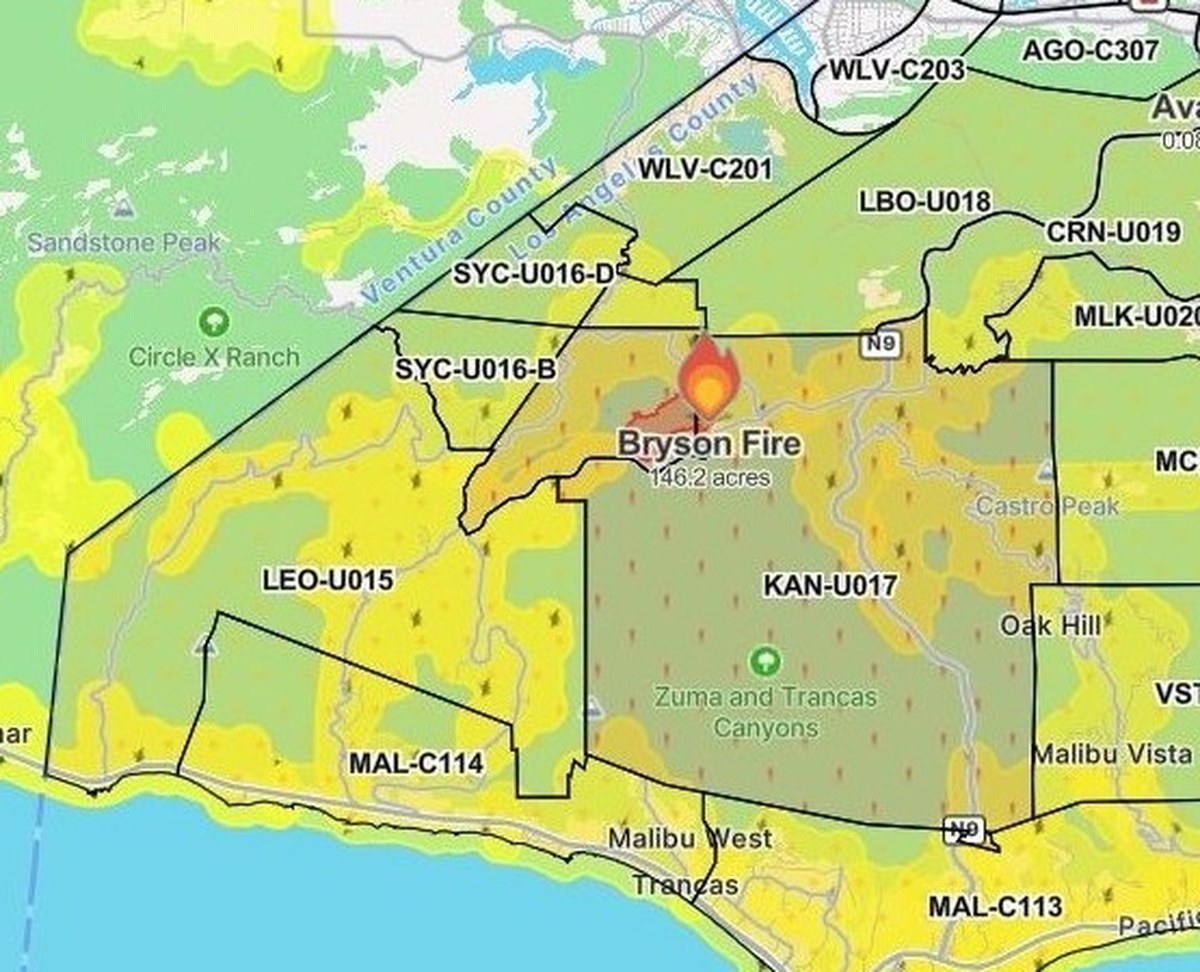
The fire began at 4:41 p.m. on October 15 near Encinal Canyon Road, west of Mulholland Highway in the Encinal Canyon area, and was reported at about 200 acres that night as evacuation orders and warnings covered multiple zones. Mapping on October 16 revised the size to about 147 acres, and containment rose through 5%, 17% and 39%; it reached 52% on October 17, and all evacuation orders and warnings were lifted at 6:20 p.m. that day. Containment reached 74% on October 18, 83% on the morning of October 19, 98% that evening and 100% at 6:44 p.m., five days after the fire started.
On damage and injuries, Los Angeles County officials previously reported no structures damaged or destroyed, and CAL FIRE's incident page lists one confirmed firefighter injury in its damage assessment. The cause remains under investigation. Roads closed by the fire had already reopened, and the resident shelter at Agoura High School and the large-animal shelter at Pierce College have closed.
Source: GSM · USA (original Chinese edition)
Photo: 图:Bryson Fire 态势图,Watch Duty 截图(10月16日20时45分截取,本轮重新裁切)。图中火场位于加州洛杉矶县 Malibu 以北 Encinal Canyon 一带,标注的146.2英亩为截取时的测绘数,与最新官方公布的约146英亩相符;图中分区为当时的疏散分区,该批疏散令与警告已于10月17日晚全部解除。最新官方数据以正文为准:加州消防局(CAL FIRE)官方事故页10月19日下午6时44分通报控制率达到100%。图片来源:Watch Duty。Situation map of the Bryson Fire, Watch Duty screenshot taken at 8:45 p.m. on Oct. 16 (re-cropped for this update). The fire sits in the Encinal Canyon area north of Malibu in Los Angeles County, California; the 146.2 acres shown is the mapping figure at capture time, consistent with the latest official figure of about 146 acres, and the zones shown are the evacuation zones then in effect, all of whose orders and warnings were lifted on the evening of Oct. 17. The latest official figures are in the text: CAL FIRE's incident page reported 100% containment at 6:44 p.m. on Oct. 19. Source: Watch Duty.
- 2026-10-15Malibu Bryson Fire Grows to at Least 40 Acres; Evacuation Order Issued for Zone KAN-U017
- 2026-10-15Follow-Up: Malibu Bryson Fire Grows to 80 Acres as Evacuation Warnings Expand to 10 Zones
- 2026-10-15Follow-Up: Malibu Bryson Fire Reported at About 200 Acres as Red Cross Opens Shelter at Agoura High School
- 2026-10-16Bryson Fire Update: Containment Rises to 39% as Mapped Acreage Is Revised to 146.2 Acres
- 2026-10-17Bryson Fire in Malibu Reaches 52% Containment; Size Holds at About 147 Acres
- 2026-10-17Update: All Bryson Fire Evacuation Orders and Warnings Lifted Near Malibu; Roads Reopened, Shelters Closed
- 2026-10-17Roundup: All Four Southern California Wildfires Moving Toward Containment — Henderson at 50%, Norte Evacuations Fully Lifted
- 2026-10-18Update: Bryson Fire Near Malibu Reaches 68% Containment; Size Holds at About 147 Acres
- 2026-10-18Update: Bryson Fire Near Malibu Reaches 74% Containment; Size Holds at About 147 Acres
- 2026-10-19Follow-Up: Bryson Fire Near Malibu Reaches 83% Containment; Size Holds at 147 Acres
- 2026-10-20Follow-Up: Bryson Fire Near Malibu Fully Contained; Size About 146 AcresThis story