Cooley Fire in Mendocino County Grows to 731 Acres at 5% Containment; No Evacuations Ordered
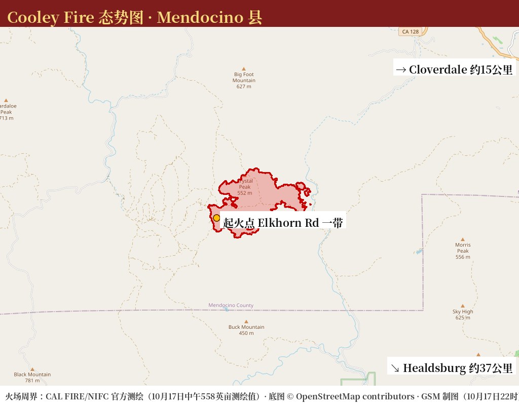
MENDOCINO COUNTY — The Cooley Fire, burning west of Cloverdale in southern Mendocino County, had grown to 731.4 acres with containment of just 5%, according to CAL FIRE's official incident data updated at 7:49 p.m. on Saturday, October 17. The fire was first reported at 5:05 p.m. on October 16 near Elkhorn Road and Cooley Ranch Road. Officials have issued no evacuation orders or warnings, and no structures have been damaged and no injuries reported.
The fire's first day, by the official updates: it stood at 40 acres by 7:50 p.m. on Friday; by 11:10 a.m. Saturday it was reported at 1,000 acres, a figure revised down to 558 acres at 12:33 p.m. after more accurate mapping; at 1:14 p.m. CAL FIRE reported 5% containment, noting that steep terrain and limited access have hampered firefighting efforts; by 5:11 p.m. the burned area had climbed again to 731 acres. The incident is under the jurisdiction of the CAL FIRE Mendocino Unit, and no incident management team has been assigned.
CAL FIRE lists the cause as under investigation. According to the Press Democrat, the fire began as a private prescribed burn on the roughly 19,000-acre Cooley Ranch that escaped its boundaries — the burn was not a CAL FIRE project — and CAL FIRE is investigating why the burn escaped, including the weather conditions and the resources on hand at the time. The Press Democrat also reported fire official Turbeville saying that low-hanging smoke was limiting the ability to use aircraft against the fire.
Smoke has been the fire's main impact beyond the burn area. The Bay Area Air Quality Management District issued an air quality advisory on Saturday morning for northern Sonoma County, where monitors recorded an AQI of 221 near Bradford Mountain outside Healdsburg — in the 'very unhealthy' range — and 160 in Geyserville, in the 'unhealthy' range.
Source: GSM · USA (original Chinese edition)
Photo: 图:Cooley Fire 态势图(GSM 据 CAL FIRE/NIFC 官方测绘周界绘制,10月17日22时)。红色周界为官方17日中午测绘的火场范围(558英亩测绘值);据加州消防局(CAL FIRE)官方事件数据17日晚7时49分更新,过火面积已升至731.4英亩、控制率5%。底图 © OpenStreetMap contributors。Situation map of the Cooley Fire, drawn by GSM from the official CAL FIRE/NIFC mapped perimeter as of midday Oct. 17 (558 mapped acres); CAL FIRE incident data updated at 7:49 p.m. on Oct. 17 put the fire at 731.4 acres and 5% containment. Base map © OpenStreetMap contributors.
- 2026-10-17Cooley Fire in Mendocino County Grows to 731 Acres at 5% Containment; No Evacuations OrderedThis story
- 2026-10-18Follow-Up: Cooley Fire in Mendocino County Remapped at 1,036 Acres, Containment Rises to 15%
- 2026-10-18Update: Cooley Fire in Mendocino County Grows to 1,156 Acres; Containment Holds at 15%
- 2026-10-19Update: Cooley Fire in Mendocino County Reaches 23% Containment; Size Holds at 1,156 Acres
- 2026-10-19Update: Cooley Fire in Mendocino County Grows to 1,364 Acres; Containment Holds at 23%
- 2026-10-19Update: Cooley Fire in Mendocino County Reaches 45% Containment at 1,364 Acres
- 2026-10-20Follow-Up: Cooley Fire Crews Begin Suppression Repair in Mendocino County; No Active Fire Seen Inside Perimeter, No Structures Damaged
- 2026-10-20Update: Cooley Fire in Mendocino County Reaches 57% Containment at 1,365 Acres
- 2026-10-20Update: Cooley Fire in Mendocino County Reaches 67% Containment at 1,365 Acres as Crews Begin Backhaul Operations
- 2026-10-23Update: Cooley Fire in Mendocino County Reaches 80% Containment at 1,365 Acres as Command Transitions to Local Unit
- 2026-10-24Update: Cooley Fire in Mendocino County Reaches 86% Containment at 1,365 Acres as 71 Personnel Continue Mop-Up
- 2026-10-24Update: Cooley Fire in Mendocino County Reaches 90% Containment at 1,365 Acres as 71 Personnel Hold the Line
- 2026-10-25Update: Cooley Fire in Mendocino County Reaches 95% Containment at 1,365 Acres as Crews Move Toward Patrol Status