Update: Cooley Fire in Mendocino County Grows to 1,364 Acres; Containment Holds at 23%
MENDOCINO COUNTY — The Cooley Fire, burning west of Cloverdale in Mendocino County, grew to 1,364 acres, according to a 2:30 p.m. update on CAL FIRE's official incident page on Monday, October 19 — an increase of 208 acres from the 1,156 acres reported at 4:49 p.m. on October 18. Containment saw no new adjustment and remains at the 23% reported at 6:51 a.m. on October 19, which officials credited to strategic fire suppression efforts.
In other official updates that day, CAL FIRE said at 1:17 p.m. that the fire information board is located in front of the Yorkville Post Office at 25400 CA-128 in Yorkville, with information updated daily. At 10:00 a.m., officials described severe logistical challenges from exceptionally steep terrain and a sparse road network limiting access for large engines, with two branches — Elkhorn to the north, in heavier brush and timber understory, and Rockpile to the south, in continuous grass — covering seven operational divisions, and crews using firing pistols to carry out firing operations in steep terrain. At 8:00 a.m., CAL FIRE said firefighters had completed overnight strategic firing operations, that a dense marine layer had formed an inversion at about 1,000 feet with dynamic fire activity above that level, and that the day would be mostly cloudy around 64 degrees with patchy smoke and fog. Officials also confirmed no structures are threatened and no power lines or critical utilities are compromised near the fire.
The fire began at 5:05 p.m. on October 16 near Elkhorn Road and Cooley Ranch Road, is under the jurisdiction of the CAL FIRE Mendocino Unit, and its cause remains under investigation. No evacuation orders or warnings have been issued for this fire at any point, and official updates have reported no structure damage or injuries; the October 19 afternoon update likewise mentioned no new evacuations, damage or injuries.
Source: GSM · USA (original Chinese edition)
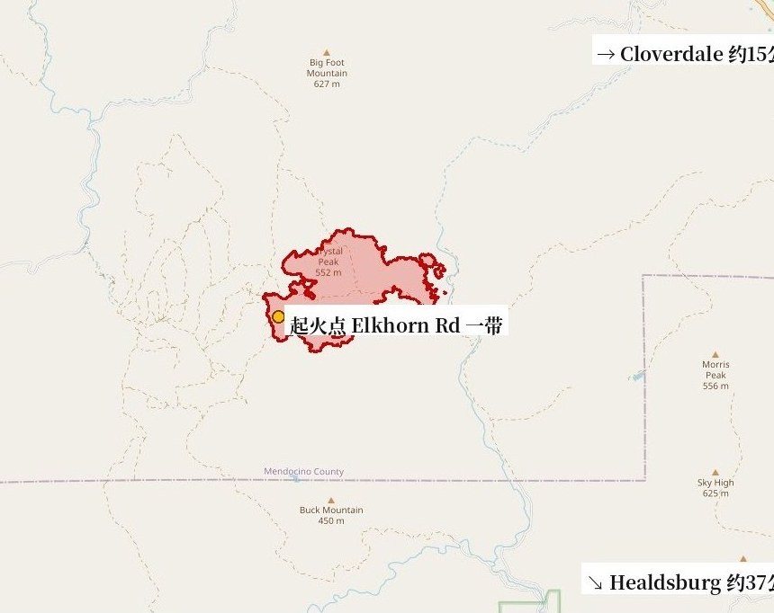
Photo: 图:Cooley Fire 态势图(GSM 据 CAL FIRE/NIFC 官方测绘周界绘制,10月17日,本轮重新裁切)。图中红色周界为17日中午官方测绘的火场范围(558英亩测绘值);最新官方数据以正文为准:过火面积1,364英亩、控制率23%(加州消防局 CAL FIRE 官方事故页10月19日下午2时30分通报面积、清晨6时51分通报控制率)。底图 © OpenStreetMap contributors。Situation map of the Cooley Fire, drawn by GSM from the official CAL FIRE/NIFC mapped perimeter as of midday Oct. 17 (558 mapped acres; re-cropped for this update). The latest official figures are in the text: 1,364 acres, with containment at 23%, per CAL FIRE updates at 2:30 p.m. and 6:51 a.m. on Oct. 19. Base map © OpenStreetMap contributors.
- 2026-10-17Cooley Fire in Mendocino County Grows to 731 Acres at 5% Containment; No Evacuations Ordered
- 2026-10-18Follow-Up: Cooley Fire in Mendocino County Remapped at 1,036 Acres, Containment Rises to 15%
- 2026-10-18Update: Cooley Fire in Mendocino County Grows to 1,156 Acres; Containment Holds at 15%
- 2026-10-19Update: Cooley Fire in Mendocino County Reaches 23% Containment; Size Holds at 1,156 Acres
- 2026-10-19Update: Cooley Fire in Mendocino County Grows to 1,364 Acres; Containment Holds at 23%This story
- 2026-10-19Update: Cooley Fire in Mendocino County Reaches 45% Containment at 1,364 Acres
- 2026-10-20Follow-Up: Cooley Fire Crews Begin Suppression Repair in Mendocino County; No Active Fire Seen Inside Perimeter, No Structures Damaged
- 2026-10-20Update: Cooley Fire in Mendocino County Reaches 57% Containment at 1,365 Acres
- 2026-10-20Update: Cooley Fire in Mendocino County Reaches 67% Containment at 1,365 Acres as Crews Begin Backhaul Operations
- 2026-10-23Update: Cooley Fire in Mendocino County Reaches 80% Containment at 1,365 Acres as Command Transitions to Local Unit
- 2026-10-24Update: Cooley Fire in Mendocino County Reaches 86% Containment at 1,365 Acres as 71 Personnel Continue Mop-Up
- 2026-10-24Update: Cooley Fire in Mendocino County Reaches 90% Containment at 1,365 Acres as 71 Personnel Hold the Line
- 2026-10-25Update: Cooley Fire in Mendocino County Reaches 95% Containment at 1,365 Acres as Crews Move Toward Patrol Status