Update: Cooley Fire in Mendocino County Reaches 67% Containment at 1,365 Acres as Crews Begin Backhaul Operations
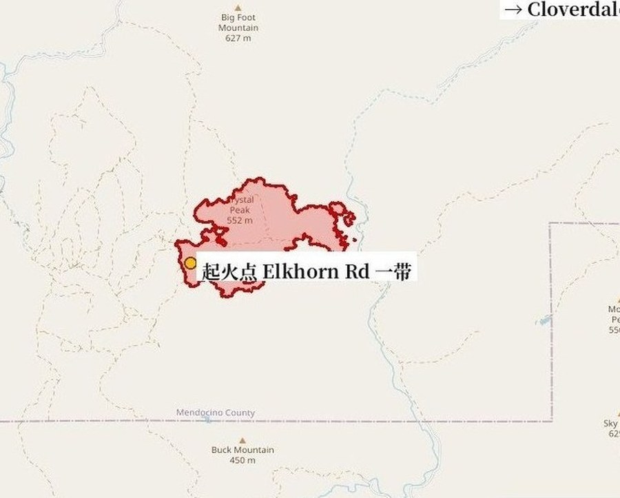
Containment of the Cooley Fire, burning west of Cloverdale in Mendocino County, California, continues to climb. CAL FIRE's official incident page, last updated at 5:37 p.m. on October 20, lists the fire at 1,365 acres with containment up to 67%, a further 10-point gain from the 57% reported earlier in the afternoon.
In its 5:28 p.m. update, CAL FIRE said crews have begun backhaul operations, retrieving hose, other used supplies and equipment from the fire line, while suppression repair is underway, focusing on road grading and erosion mitigation where dozer lines were put in. The agency stated explicitly that no structures were damaged or destroyed during this incident. To optimize personnel and equipment, the Elkhorn Branch on the fire's northern portion and the Rockpile Branch on the southern flank will merge resources tomorrow, October 21, and the incident base camp in Cloverdale is expected to close by the end of the week.
According to the incident page, 869 personnel, 47 engines, 33 crews, 10 dozers and 10 water tenders are assigned, along with 102 other assigned personnel, and numerous air tankers from across the state are flying suppression missions as conditions allow. The fire started at 5:05 p.m. on October 16 near Elkhorn Road and Cooley Ranch Road; its cause remains under investigation, and no evacuation orders or warnings have been issued in any official update.
Source: GSM · USA (original Chinese edition)
Photo: 图:Cooley Fire 态势图(GSM 据 CAL FIRE/NIFC 官方测绘周界绘制,10月17日,本轮以新幅面重新裁切)。图中红色周界为17日官方测绘的火场范围;最新官方数据以正文为准:过火面积1,365英亩、控制率67%(加州消防局 CAL FIRE 官方事故页10月20日下午5时37分更新)。底图 © OpenStreetMap contributors。 Situation map of the Cooley Fire, drawn by GSM from the official CAL FIRE/NIFC mapped perimeter as of Oct. 17 (re-cropped this round with a new framing). The latest official figures are in the text: 1,365 acres and 67% containment, per CAL FIRE's incident page update at 5:37 p.m. on Oct. 20. Base map © OpenStreetMap contributors.
- 2026-10-17Cooley Fire in Mendocino County Grows to 731 Acres at 5% Containment; No Evacuations Ordered
- 2026-10-18Follow-Up: Cooley Fire in Mendocino County Remapped at 1,036 Acres, Containment Rises to 15%
- 2026-10-18Update: Cooley Fire in Mendocino County Grows to 1,156 Acres; Containment Holds at 15%
- 2026-10-19Update: Cooley Fire in Mendocino County Reaches 23% Containment; Size Holds at 1,156 Acres
- 2026-10-19Update: Cooley Fire in Mendocino County Grows to 1,364 Acres; Containment Holds at 23%
- 2026-10-19Update: Cooley Fire in Mendocino County Reaches 45% Containment at 1,364 Acres
- 2026-10-20Follow-Up: Cooley Fire Crews Begin Suppression Repair in Mendocino County; No Active Fire Seen Inside Perimeter, No Structures Damaged
- 2026-10-20Update: Cooley Fire in Mendocino County Reaches 57% Containment at 1,365 Acres
- 2026-10-20Update: Cooley Fire in Mendocino County Reaches 67% Containment at 1,365 Acres as Crews Begin Backhaul OperationsThis story
- 2026-10-23Update: Cooley Fire in Mendocino County Reaches 80% Containment at 1,365 Acres as Command Transitions to Local Unit
- 2026-10-24Update: Cooley Fire in Mendocino County Reaches 86% Containment at 1,365 Acres as 71 Personnel Continue Mop-Up
- 2026-10-24Update: Cooley Fire in Mendocino County Reaches 90% Containment at 1,365 Acres as 71 Personnel Hold the Line
- 2026-10-25Update: Cooley Fire in Mendocino County Reaches 95% Containment at 1,365 Acres as Crews Move Toward Patrol Status